

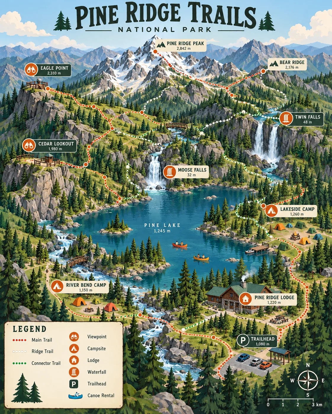
Park Trail Map, made with GPT Image 2.5 Sunburst
Example made with GPT Image 2.5 Sunburst

Text to imageInfographics & diagrams

GPT Image 2.5 Sunburst illustrated map promptPark Trail Map

The exact text-to-image prompt behind this picture, made with GPT Image 2.5 Sunburst.

Prompt

Vertical 4:5 portrait frame. A stylized illustrated map of a mountain national park in isometric style: trails in dotted lines, waterfalls, a lake with canoes, viewpoints, campsites with tiny tents and a lodge, soft greens and blues with tangerine markers, a clean legend box in the corner, a title at the top that reads "PINE RIDGE TRAILS".

Prompts are kept in their original English to help reproduce the example. Copy one as it is, or adapt it for your project.

Opens GPT Image 2.5 Sunburst with this prompt and the settings below filled in.

135 tested GPT Image prompts →

Settings

Mode
Text to image
Aspect ratio
4:5
Quality
high
Price
From 2 credits

The exact price shows before you generate.

Make your own version

  1. The words in quotes, "PINE RIDGE TRAILS", are printed in the picture. Keep them short and change them to your own.

Where this idea comes from

Inspired by an idea from Jared Liu, collected in YouMind-OpenLab/awesome-seedream-4.5 under CC BY 4.0. PopNow wrote this prompt and made the example above.

Style prompt guide

Style traits to keep

A stylized mountain park map in an isometric vector style creates an inviting, clean visitor brochure aesthetic. The prompt works reliably in GPT Image 2.5 Sunburst because it establishes a strict hierarchy: muted environmental tones sit behind high-contrast tangerine markers, while precise quotes anchor the header text and keep the layout neat.

This illustrated map style balances vector clarity with playful miniature details to turn geographical data into an approachable visual guide.

Perspective
An isometric angle reveals terrain elevation, river paths, and architectural structures simultaneously without wide-angle camera distortion.
Palette
Understated natural greens and river blues form a restful backdrop, ensuring bright tangerine accents pop instantly for wayfinding.
Line
Dotted vector paths provide a distinct graphical texture that separates designated trails from natural riverbanks and ridgelines.
Composition
A dedicated header zone and corner legend box frame the natural landscape, turning an organic scene into a structured graphic publication.

What defines this look

  1. layout and camera perspectiveVertical 4:5 portrait frame. A stylized illustrated map of a mountain national park in isometric style:

    Establishes the tall brochure format and an elevated three-dimensional angle. Removing the isometric reference causes the model to generate either a flat overhead satellite scan or an ordinary scenic landscape painting.

  2. iconographic landmark inventorytrails in dotted lines, waterfalls, a lake with canoes, viewpoints, campsites with tiny tents and a lodge,

    Pockets the landscape with miniature storytelling details that define human recreation scale. Without these explicit landmarks, the model fills the scene with empty, repetitive mountain ridges.

  3. contrasting color palettesoft greens and blues with tangerine markers,

    Enforces functional cartographic contrast between terrain bases and navigation points. Omitting the vibrant tangerine accent lets trail icons dissolve into the surrounding green canopy.

  4. typography and editorial framinga clean legend box in the corner, a title at the top that reads "PINE RIDGE TRAILS".

    Directs the model to generate legible header lettering and an organized infographic border. Quoting the exact title keeps the generator from scattering pseudo-text gibberish across the sky.

Same style, new subjects

Historic City Map

Applies the clean isometric vector aesthetic to cobblestone streets, canal networks, and architectural monuments.

Prompt

Vertical 4:5 portrait frame. A stylized illustrated map of a historic European city center in isometric style: pedestrian routes in dotted lines, stone bridges, a canal with tour boats, museum plazas, sidewalk cafes with striped awnings and a clock tower, terracotta reds and soft grays with turquoise markers, a clean legend box in the corner, a title at the top that reads "OLD TOWN WALK".

Botanical Garden Guide

Uses the same illustrated infographic framework for cultivated gardens, glasshouses, and visitor rest stops.

Prompt

Vertical 4:5 portrait frame. A stylized illustrated map of a botanical arboretum in isometric style: walking paths in dotted lines, tiered fountains, a glass greenhouse conservatory, rose pavilions, shaded benches under willow trees and a cafe terrace, sage greens and pale blush with sunflower yellow markers, a clean legend box in the corner, a title at the top that reads "ORCHID VALLEY".

Seaside Marina Map

Transfers the miniature trail and legend formula to a nautical waterfront with piers and maritime waypoints.

Prompt

Vertical 4:5 portrait frame. A stylized illustrated map of a coastal harbor town in isometric style: boardwalks in dotted lines, rocky coves, a deep harbor with sailboats, scenic lookouts, seafood shacks with wooden docks and a striped lighthouse, slate blues and sandy ochres with coral red markers, a clean legend box in the corner, a title at the top that reads "COBALT BAY".

Model and settings

Keep the aspect ratio at 4:5 because the tall portrait orientation gives adequate vertical clearance for the header title, mountain range, and corner legend. Quality should remain on high so GPT Image 2.5 Sunburst draws clean character shapes for the title and maintains crisp trail dashes. If you want a wide wall-mounted map, switch the aspect ratio to a horizontal format while keeping quality on high.

  • Nano Banana ProChoose Nano Banana Pro if you want to pack the map with dense labels and multi-tier keys, as it plans layout structures first for complex diagrams.

When the style drifts

The image renders as a photographic drone shot instead of an illustrated graphic guide.
Replace "A stylized illustrated map" with "A clean 2D vector illustrated infographic map, flat graphic design poster art".
Dotted trails blur into thick, smudge-like road textures that overpower the scenery.
Add the words "fine minimalist dashed lines with clean spacing" directly after the trail mention.
The top title produces misspelled or illegible letterforms across the frame.
Keep the quoted phrase short, under three words, and remove any secondary subtitle requests from the prompt.

Questions about this style prompt

Why is the text inside the corner legend box unreadable?

Image models can handle large headline titles like PINE RIDGE TRAILS cleanly, but tiny paragraph-sized symbols remain difficult to render legibly. Keep your prompt focused on asking for a clean legend box graphic rather than requesting specific small text lines inside it.

Can I add topographical contour lines without cluttering the map?

Yes. Add "subtle topographic contour lines in muted beige" directly after the mountain description. This tells the model to add soft geometric elevation rings that do not fight with the dotted trail markings.

How do I change the season from summer to autumn?

Replace "soft greens and blues" with "golden ambers, burnt orange foliage, and slate blue waters". Keep the "tangerine markers" or switch them to "bright crimson markers" to preserve the high-contrast navigation points.